 EMODnet Product Catalogue
Land cover
Type of resources
Available actions
Topics
Keywords
Contact for the resource
Provided by
Years
Formats
Representation types
Update frequencies
Scale 1:
-
The dataset on Marine Protected Areas (MPAs) established under the framework of the Regional Sea Conventions (RSCs) was created in 2023 by Cogea for the European Marine Observation and Data Network (EMODnet). It is based on spatial data provided by HELCOM (HELCOM_MPAs_2019_2), by SPA/RAC and MedPAN through the MAPAMED database (MAPAMED_SPAMI_2019_edition_version_2), and by OSPAR (OSPAR_MPAs_202107_001). It is available for viewing and download on EMODnet web portal (Human Activities, https://emodnet.ec.europa.eu/en/human-activities). The dataset displays all the MPAs as officially reported by the respective Contracting Parties to the Helsinky Convention, to the Barcelona Convention and to the Convention for the Protection of the Marine Environment of the North-East Atlantic. The RSCs MPAs are established in order to promote the cooperation in the management and conservation of natural areas, as well as in the protection of threatened species and their habitats. Each RSC MPA may be established in the marine and coastal zones subject to the sovereignty or jurisdiction of the Parties and in areas situated partly or wholly on the high sea. Thus, the dataset covers the MPAs Beyond National Jurisdiction (ABNJ) and the MPAs in following countries: Albania, Algeria, Belgium, Cyprus, Denmark, Estonia, Finland, France, Germany, Iceland, Ireland, Italy, Latvia, Lebanon, Lithuania, Monaco, Morocco, the Netherlands, Norway, Poland, Portugal, Russia, Slovenia, Spain, Sweden, Tunisia, and the United Kingdom. Where available each polygon has the following attributes: code, name (english and/or original), designation, country, status (adopted/designated, managed or partly managed, proposed), establishement year, area sqkm (reported, calculated), marine area sqkm (reported, calculated) management authorithy, site link. For further information please visit the data providers websites. This dataset covers the last updated versions in the 2021 and 2022.
-
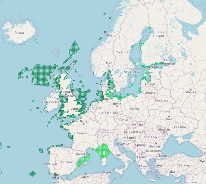
The dataset on Emerald Network sites was created in 2023 by Cogea for the European Marine Observation and Data Network. It is entirely based on spatial data from the European Environmental Agency (EEA), plus additional infos and selected EEA tabular data added as feature attributes. It is available for viewing and download on EMODnet web portal (Human Activities, https://emodnet.ec.europa.eu/en/human-activities). The Emerald Network is an ecological network made up of Areas of Special Conservation Interest designated under Recommendation No. 16 (1989) and Resolution No. 3 (1996) of the Standing Committee to the Bern Convention. The objective of the Emerald Network is the long-term survival of the species and habitats. The Network involves all the European Union member States (the European Union contributes to the Emerald Network with its Natura 2000 sites), some non-Community States and a number of African States. The dataset cover the following countries: Albania, Andorra, Armenia, Azerbaijan, Belarus, Bosnia and Herzegovina, Georgia, Iceland, Liechtenstein, Moldova, Montenegro, North Macedonia, Norway, Russian Federation (European part), Serbia, Switzerland, Ukraine and the United Kingdom. In the webmap the dataset has been filtered in order to show only marine and coastal sites. Where available each polygon has the following attributes: site code, site name, country code, country name, site type/description (A: SPA, Special Protection Areas - sites designated under the Birds Directive; B: SCIs and SACs, Sites of Community Importance and Special Areas of Conservation - sites designated under the Habitats Directive; C: where SPAs and SCIs/SACs boundaries are identical, sites are designated under both directives), site status (Proposed, Candidate or Adopted), compilation date, update date, area (ha), marine area percentage, marine/coastal location (1). For further information (e.g. biogeographic region, designation status, sites, habitats, impact, management, species and metadata) please visit the EEA's website hosting the Emerald tabular data (https://www.eea.europa.eu/data-and-maps/data/emerald-network-data-1/emerald-tabular-data). This version covers the reporting in 2021.
-

The EMODnet Bathymetry World Coastline is available as a WFS service from EMODnet Bathymetry. The service URL is: https://ows.emodnet-bathymetry.eu/wfs. The layer contains vector lines derived from land polygons available from OpenStreetMap. The original source url is https://osmdata.openstreetmap.de/. Parts of these polygons have been modified for use in EMODnet Bathymetry. In addition to the OSM EMODnet default coastline, three sub-layers are available as part of the EMODnet world coastline service. These sub-layers contain the best-estimate coastlines for Europe determined by Dutch research institute Deltares from satellite data (typically Sentinel-2 and Landsat-8) and in combination with the Global Tide Surge Model (GTSM) processed into digital coastlines for the European seas at LAT (Lowest Astronomical Tide), MSL (Mean-Sea-Level), and MHW (Mean-High-Water). The level of detail is bound to the resolution of the satellite sensor (e.g. 10m for Sentinel-2). The latest December 2022 version covers the entire coastline of Europe and now also part of the Caribbean. A detailed paper is available describing the methodology used to determine the three versions of the satellite derived coastline: https://emodnet.ec.europa.eu/sites/emodnet.ec.europa.eu/files/public/EMODnet-Bathymetry_2022_satellite_derived_coastlines_Deltares-Feb2023.pdf
-
The dataset on coastal and marine protected areas in the European seas for those countries or territories that are not covered by the the EEA's Common Database on Designated Areas (CDDA) was created in 2022 by Cogea for the European Marine Observation and Data Network (EMODnet). This dataset is entirely based on GIS vector data from UNEP-WCMC and IUCN 2023, (Protected Planet: The World Database on Protected Areas, WDPA, [Online], September 2023, Cambridge, UK: UNEP-WCMC and IUCN, available at: www.protectedplanet.net), plus additional info and selected tabular data added as feature attributes, as well as the calculation of marine and coastal location of features. It is available for viewing and download on EMODnet web portal (Human Activities, https://emodnet.ec.europa.eu/en/human-activities). The WDPA is the most comprehensive global database of marine and terrestrial protected areas, it is a joint project between UN Environment Programme (UNEP) and the International Union for Conservation of Nature (IUCN), and it is managed by the UNEP World Conservation Monitoring Centre (UNEP-WCMC), in collaboration with governments, non-governmental organisations, academia and industry. In the webmap the dataset has been filtered in order to show only marine and coastal areas. Geographical coverage: Algeria, Antigua and Barbuda, Barbados, Belize, Colombia, Costa Rica, Cuba, Denmark (only the Faroe Islands), Dominica, Dominican Republic, Egypt, France (only Guadeloupe, Martinique, Saint Barthélemy, Saint Martin French part), Georgia, Grenada, Guatemala, Haiti, Honduras, Israel, Jamaica, Lebanon, Mexico, Monaco, Morocco, Netherlands (only Aruba, Curaçao, Bonaire, Sint Eustatius and Saba, Sint Maarten Dutch part) Nicaragua, Norway (only Svalbard and Jan Mayen), Palestine, Panama, Russian Federation, Saint Kitts and Nevis, Saint Lucia, Saint Vincent and the Grenadines, Trinidad and Tobago, Tunisia, Turkey, Ukraine, United Kingdom (including Anguilla, British Virgin Islands, Cayman Islands, Guernsey, Isle of Man, Jersey, Montserrat), United States (only Puerto Rico, the US Virgin Islands and the US Minor Outlying Islands in the Caribbean Sea), Venezuela. Where available each polygon has the following main attributes: country code, territory code, country name, territory name, WDPA ID, name (english and original), designation name (english and original) and type (International, National, Not Applicable, Regional), IUCN category and description (Ia: Strict Nature Reserve; Ib: Wilderness Area; II: National Park; III: Natural Monument or Feature; IV: Habitat/Species Management Area; V: Protected Landscape/ Seascape; VI: Protected area with sustainable use of natural resources; Not applicable; Not assigned; Not reported), marine location (1: predominantly marine; 2: entirely marine), area sqkm (reported, calculated), marine area sqkm (reported, calculated), status (Adopted, Designated, Established, Inscribed, Not Reported, Proposed), government type (Collaborative governance, Federal or national ministry or agency, For-profit organisations, Government-delegated management, Indigenous peoples, Individual landowners, Joint governance, Local communities, Non-profit organisations, Not Reported, Sub-national ministry or agency), ownership type (Communal, For-profit organisations, Individual landowners, Joint ownership, Multiple ownership, Non-profit organisations, Not Reported, State), management authorithy and plan info, marine/coastal location (1). For further information please visit the Protected Planet website. Compared with the previous release, this one includes the updated dataset 'WDPA_Sep2023_Public' published by the WDPA in September 2023 and it includes the marine and coastal protected areas in the Caribbean Sea.
-
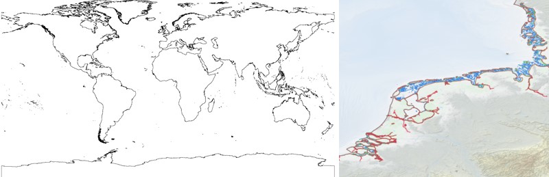
The EMODnet Bathymetry World Coastline is available as a WFS service from EMODnet Bathymetry. The service URL is: https://ows.emodnet-bathymetry.eu/wfs. The layer contains vector lines derived from land polygons available from OpenStreetMap. The original source url is https://osmdata.openstreetmap.de/. Parts of these polygons have been modified for use in EMODnet Bathymetry. In addition to the OSM EMODnet default coastline, three sub-layers are available as part of the EMODnet world coastline service. These sub-layers contain the best-estimate coastlines for Europe determined by Dutch research institute Deltares from satellite data (typically Sentinel-2 and Landsat-8) and in combination with the Global Tide Surge Model (GTSM) processed into digital coastlines for the European seas at LAT (Lowest Astronomical Tide), MSL (Mean-Sea-Level), and MHW (Mean-High-Water). The level of detail is bound to the resolution of the satellite sensor (e.g. 10m for Sentinel-2). The latest December 2020 version now covers the entire coastline of Europe. A detailed paper is available describing the methodology used to determine the three versions of the satellite derived coastline: https://emodnet.ec.europa.eu/sites/emodnet.ec.europa.eu/files/public/20201219_emodnet_bathymetry_satellite_derived_coastline_report.pdf
-
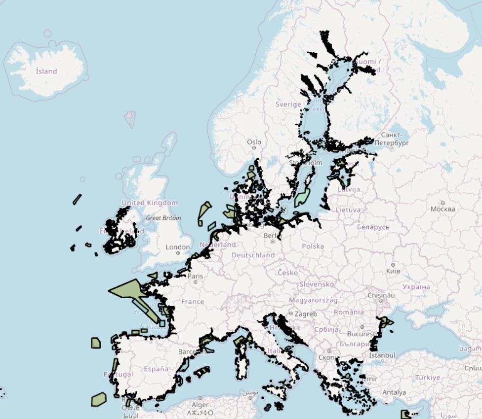
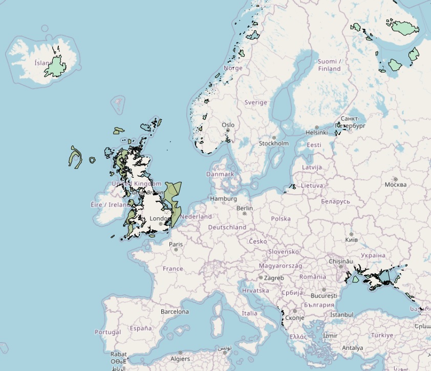
The dataset on Natura 2000 sites was created in 2014 by Cogea for the European Marine Observation and Data Network. It is entirely based on spatial data from the European Environmental Agency (EEA), plus additional info, links and selected EEA data joined to the feature attributes, as well as a calculation by Cogea of marine and coastal location of features. It is available for viewing and download on EMODnet - Human Activities web portal (https://emodnet.ec.europa.eu/en/human-activities). Natura 2000 is an ecological network composed of sites designated under the Birds Directive (Special Protection Areas, SPAs) and the Habitats Directive (Sites of Community Importance, SCIs, and Special Areas of Conservation, SACs). The dataset covers the whole EU. Following the United Kingdom’s withdrawal from the EU on 31 January 2020, it ceased to be part of the EEA’s institutional networks and governance. In the webmap the EEA dataset has been filtered by Cogea to show only (i) marine sites, i.e. sites with a marine area percentage higher than 0 (as calculated by the EEA) and (ii) sites that, even if not identified as marine by the EEA, intersect the EEA coastline or that are within a distance of 1 km from the coastline (using a 1 km inner buffer from the EEA coastline). In both cases the COAST_MAR field value=1. The EEA coastline dataset is available at https://www.eea.europa.eu/data-and-maps/data/eea-coastline-for-analysis-2. Compared with the previous version, this one includes the updated dataset 'Natura 2000 End 2021', published by the EEA in April 2021. For further information (e.g. biogeographic region, directive, habitats, sites, impact, management, species and metadata) please visit the EEA's website hosting the Natura 2000 tabular data.
-
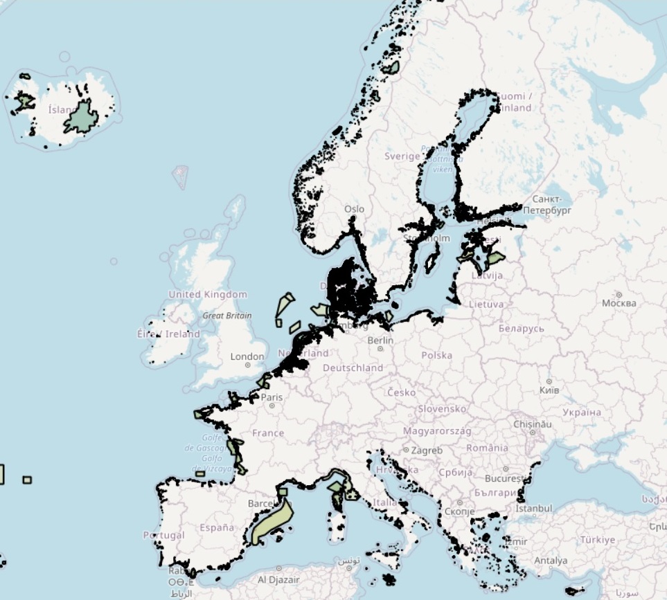
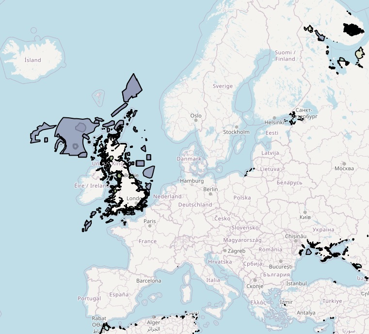
The dataset on Common Database on Designated Areas (CDDA) was created in 2014 by Cogea for the European Marine Observation and Data Network. This dataset is entirely based on GIS Data from the European Environmental Agency (EEA), plus additional info and selected EEA tabular data added as feature attributes, as well as the Cogea's calulation of marine and coastal location of features. It is available for viewing and download on EMODnet web portal (Human Activities, https://emodnet.ec.europa.eu/en/human-activities). The CDDA is commonly known as 'Nationally designated areas' and it is the official source of protected areas information from the 38 European countries, members of the Eionet, to the World Database of Protected Areas (WDPA). The data are delivered by the Eionet partnership countries as spatial and tabular information. The inventory began in 1995 under the CORINE programme of the European Commission. It is now one of the agreed Eionet priority data flows maintained by EEA with support from the European Topic Centre on Biological Diversity. The dataset is used by the EEA and e.g. the UNEP-WCMC for their main European and global assessments, products and services. Geographical coverage: Albania, Austria, Belgium, Bosnia and Herzegovina, Bulgaria, Croatia, Cyprus, Czech Republic, Denmark, Estonia, Finland, France, Germany, Greece, Hungary, Iceland, Ireland, Italy, Kosovo (under UNSC Resolution 1244/99), Latvia, Liechtenstein, Lithuania, Luxembourg, Malta, Montenegro, Netherlands, North Macedonia, Norway, Poland, Portugal, Romania, Serbia, Slovakia, Slovenia, Spain, Sweden and Switzerland. EEA does not have permission to distribute some or all sites reported by Estonia, Ireland and Turkey. In the webmap the dataset has been filtered in order to show only marine and coastal areas. Where available each polygon has the following main attributes: CDDA ID, country code, country name, site name, legal foundation date, national ID, area type/code (Designated Boundary or Site), IUCN category/description (Ia: Strict Nature Reserve; Ib: Wilderness Area; II: National Park; III: Natural Monument or Feature; IV: Habitat/Species Management Area; V: Protected Landscape/ Seascape; VI: Protected area with sustainable use of natural resources; Not applicable; Not assigned; Not reported), area (ha), major ecosystem type (Marine, Marine and terrestrial, Terrestrial), marine area percentage, spatial resolution (Scale 100K-250K, Scale Larger 100K, Unknown), remarks, marine/coastal location (1). For further information please visit the EEA's website. Compared with the previous release, this one includes the updated dataset 'CDDA_2023_v01_public' published by the EEA in June 2023.
-
This report describes the results from an interdisciplinary field survey aimed at identifying the location, extent and condition of Annex I habitat features in the Large Shallow Inlet and Bay of The Wash and North Norfolk Coast SAC. The habitat features of interest are (i) subtidal boulder and cobble communities, and (ii) Sabellaria spinulosa reefs. Information presented is intended to serve as a baseline for future monitoring of the identified features. Acoustic sidescan data were acquired from selected areas within the broader SAC area, together with grountruthing samples representative of distinct acoustic signatures. Groundtruthing techniques included the acquisition of video and still images of the seabed and of sediment and faunal sample. Of particular interest was an area to the north of the eastern Well survey area between 10 and 47 m deep which exhibited a high density of hard and rugged features, confirmed as boulder and cobble reef on chalk bedrock by the photographic record. This area also harboured a high number of epifaunal taxa not observed in the surrounding sediments. The area has been delimited and covers approximately 470 ha. The acoustic record did not reveal the occurrence of areas of Sabellaria spinulosa reef. Infaunal samples did collect representatives of this species but in densities too small to be considered as reef. At most sites where S. spinulosa was observed, the abundance and diversity of the whole infaunal assemblage was higher than in areas where S. spinulosa was absent. Analysis of both infaunal and epifaunal assemblages revealed several distinct communities throughout the survey area.